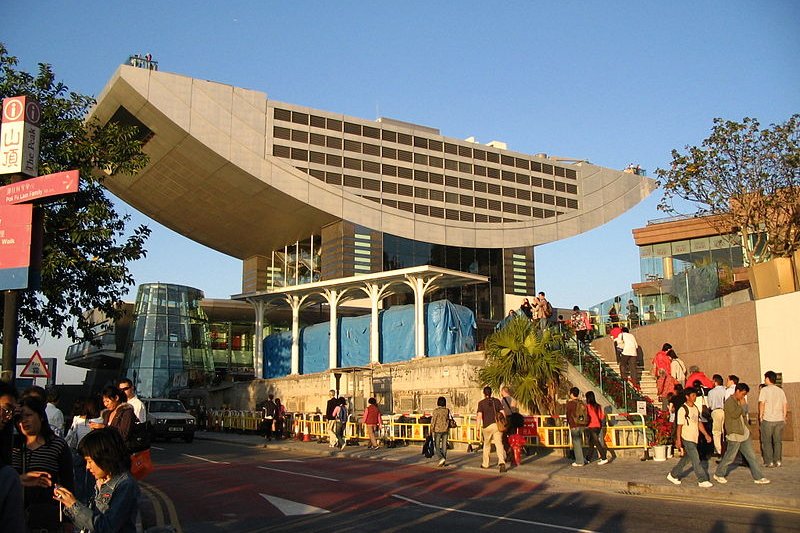
 Peak Tower, Victoria Peak, Hong Kong
Source: http://commons.wikimedia.org/wiki/File:Peak_Tower_1.jpg
Author: Minghong

Victoria Peak 太平山 is the tallest point on Hong Kong Island. Also called The Peak, and less commonly as Mount Austin, it stands at 552 m (1,811 ft) above sea level. Althought the highest point on Hong Kong Island, it is only the 31st highest mountain in the entire Hong Kong SAR, where the tallest mountain is the 957-meter Tai Mo Shan in the New Territories.
The very top of Victoria Peak is surmounted by a telecommunications facility and off-limits to the public. The surrounding areas are a parkland with various view points of Hong Kong Island and the surrounding region. Some of the most expensive residential properties in Hong Kong are located in the vicinity, commanding an almost "aerial view" of everything below.
How to go to Victoria Peak
The main way to reach the top of Victoria Peak is by taking the Peak Tramway. The Lower Terminus of the Peak Tramway is at Garden Road, near St John's Cathedral. You can reach it on foot from the Central MTR Station or Admiralty MTR Station. The tram operates daily from 7:00 am to 12:00 midnight every day including public holidays.What to see in Victoria Peak
- Peak Tower
Probably the most popular landmark of the Peak, this is the upper terminal of the Peak Tram that also houses a shopping arcade. - Peak Galleria
This is the shopping mall adjoining Peak Tower. - Victoria Peak Garden
Chinese-style public garden with a view point overlooking Victoria Harbour.
 Latest updates on Penang Travel Tips
 Discover with Timothy YouTube Channel
 PG Food Channel
 Learn Penang Hokkien YouTube Channel
 SojiMart Videos
 Share your travels and/or ask a travel-related question
Join the Penang Travel Tips Facebook Group to share photos, tips and anything related to your travels, or ask travel-related questions.
 Map of Roads in Penang
Looking for information on Penang? Use this Map of Roads in Penang to zoom in on information about Penang, brought to you road by road. Discover with Timothy
Let me take you to explore and discover Penang through my series of walking tours on YouTube. You may use these videos as your virtual tour guide. At the beginning of each video, I provide the starting point coordinates which you may key into your GPS, Google Maps or Waze, to be navigated to where I start the walk, and use the video as your virtual tour guide.Disclaimer
Please use the information on this page as guidance only. The author endeavours to update the information on this page from time to time, but regrets any inaccuracies if there be any.Latest from Discover with Timothy: Gurney Bay - what to see and do there
About this website

Hello and thanks for reading this page. My name is Timothy and my hobby is in describing places so that I can share the information with the general public. My website has become the go to site for a lot of people including students, teachers, journalists, etc. whenever they seek information on places, particularly those in Malaysia and Singapore. I have been doing this since 5 January 2003, for over twenty years already. You can read about me at Discover Timothy. By now I have compiled information on thousands of places, mostly in Peninsular Malaysia and Singapore, and I continue to add more almost every day. My goal is to describe every street in every town in Malaysia and Singapore.
Robbie's Roadmap
- Episode 1: Robbie's Journey to Financial Freedom
- Episode 2: Lost in America
- Episode 3: The Value of Money
- Episode 4: The Mentor
- Episode 5: The Thing that Makes Money
- Episode 6: The walk with a Billionaire
- Episode 7: The Financial Freedom Awakening
- Episode 8: Meet Mr Washington
- Episode 9: The Pizzeria Incident
Copyright © 2003-2024 Timothy Tye. All Rights Reserved.


 Go Back