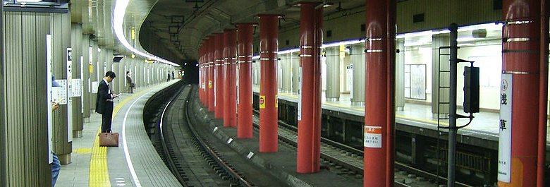
 Asakusa Line
Source: https://commons.wikimedia.org/wiki/File:Toei-asakusa-sta-platform.jpg
Author: LERK 所有のファイル

The Asakusa Line (A) 浅草線 is a line of the Tokyo Subway operated by the Tokyo Metropolitan Bureau of Transportation (Toei). It runs from the Nishi-Magome Subway Station to the Oshiage Subway Station. The total distance traveled is 18.4 km (11.43 mi) with 20 stations along the way number A-01 to A-20.
Line color: rose
Stations on the Asakusa Line
| Station Number | Station Name in English | Station Name in Japanese | Interchange(s) |
| A-01 | Nishi-Magome Subway Station | 西馬込 | NONE |
| A-02 | Magome Subway Station | 馬込 | NONE |
| A-03 | Nakanobu Subway Station | 中延 | Oimachi Line |
| A-04 | Togoshi Subway Station | 戸越 | NONE |
| A-05 | Gotanda Subway Station | 五反田 | Yamanote Line, Ikegami Line |
| A-06 | Takanawadai Subway Station | 高輪台 | NONE |
| A-07 | Sengakuji Subway Station | 泉岳寺 | Keikyu Main Line |
| A-08 | Mita Subway Station | 三田 | Mita Line (I-04), Keihin-Tohoku Line |
| A-09 | Daimon Subway Station | 大門 | Oedo Line (E-20), Haneda Line |
| A-10 | Shimbashi Subway Station | 新橋 | Ginza Line (G-08), Tokaido Line, Yokosuka Line |
| A-11 | Higashi-Ginza Subway Station | 東銀座 | Hibiya Line (H-09) |
| A-12 | Takaracho Subway Station | 宝町 | NONE |
| A-13 | Nihombashi Subway Station | 日本橋 | Ginza Line (G-11) |
| A-14 | Ningyocho Subway Station | 人形町 | Hibiya Line (H-13) |
| A-15 | Higashi-Nihombashi Subway Station | 東日本橋 | Shinjuku Line (S-09), Sobu Line |
| A-16 | Asakusabashi Subway Station | 浅草橋 | Chuo-Sobu Line |
| A-17 | Kuramae Subway Station | 蔵前 | Oedo Line (E-11) |
| A-18 | Asakusa Subway Station | 浅草 | Ginza Line (G-19), Isesaki Line |
| A-19 | Honjo-Azumabashi Subway Station | 本所吾妻橋 | NONE |
| A-20 | Oshiage Subway Station | 押上 | Oshiage Line, Hanzomon Line (Z-14), Isesaki Line |
 Latest updates on Penang Travel Tips
 Discover with Timothy YouTube Channel
 PG Food Channel
 Learn Penang Hokkien YouTube Channel
 SojiMart Videos
 Share your travels and/or ask a travel-related question
Join the Penang Travel Tips Facebook Group to share photos, tips and anything related to your travels, or ask travel-related questions.
 Map of Roads in Penang
Looking for information on Penang? Use this Map of Roads in Penang to zoom in on information about Penang, brought to you road by road. Discover with Timothy
Let me take you to explore and discover Penang through my series of walking tours on YouTube. You may use these videos as your virtual tour guide. At the beginning of each video, I provide the starting point coordinates which you may key into your GPS, Google Maps or Waze, to be navigated to where I start the walk, and use the video as your virtual tour guide.Disclaimer
Please use the information on this page as guidance only. The author endeavours to update the information on this page from time to time, but regrets any inaccuracies if there be any.Latest from Discover with Timothy: Gurney Bay - what to see and do there
About this website

Hello and thanks for reading this page. My name is Timothy and my hobby is in describing places so that I can share the information with the general public. My website has become the go to site for a lot of people including students, teachers, journalists, etc. whenever they seek information on places, particularly those in Malaysia and Singapore. I have been doing this since 5 January 2003, for over twenty years already. You can read about me at Discover Timothy. By now I have compiled information on thousands of places, mostly in Peninsular Malaysia and Singapore, and I continue to add more almost every day. My goal is to describe every street in every town in Malaysia and Singapore.
Robbie's Roadmap
- Episode 1: Robbie's Journey to Financial Freedom
- Episode 2: Lost in America
- Episode 3: The Value of Money
- Episode 4: The Mentor
- Episode 5: The Thing that Makes Money
- Episode 6: The walk with a Billionaire
- Episode 7: The Financial Freedom Awakening
- Episode 8: Meet Mr Washington
- Episode 9: The Pizzeria Incident
Copyright © 2003-2024 Timothy Tye. All Rights Reserved.


 Go Back