
Arkansas
 Go Back - Latest PENANG Sights/Streets/New Properties > Malaysia > World | Hokkien : Lessons : Dictionary | YouTube | Facebook | About Me : Contact Me
 Big Dam Bridge across the Arkansas River at Little Rock
Source: https://commons.wikimedia.org/wiki/File:Big_Dam_Bridge_3.jpg
Author: Kmerckx

Arkansas (pronounced ar-kern-saw) is a landlocked state on the southern region of the United States. The Mississippi River forms much of the eastern border of the state, across which are the states of Tennessee and Misssissippi. To the south is Louisiana, to the southwest Texas, to the west is Oklahoma and to the north is Missouri. The state capital, Little Rock, is located at the heart of Arkansas.
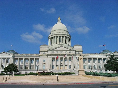
 Arkansas State Capitol
Source: https://commons.wikimedia.org/wiki/File:Arkansas_State_Capitol,_Little_Rock.jpg
Author: jglazer75

The name Arkansas comes from the same word that we get Kansas. The name Arkansas comes from the French spelling of the Quapaw Native American word "akakaze," which means "land of downriver people," in reference to the Quapaw tribe that used to live in the Arkansas area. There was a disagreement in 1881 over how the name Arkansas should be pronounced, with one senator proposing that it should be "ar-kairn-ses". However, the pronunciation "ar-kern-saw" eventually prevailed.
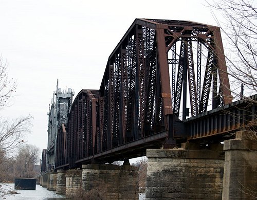
 Railroad Bridge at Fort Smith, Arkansas
Source: https://commons.wikimedia.org/wiki/File:Railroad_Bridge_In_Fort_Smith.jpg
Author: Doug Wertman

The terrain of Arkansas covers mountains, valleys and plains. In general, the state can be classified under two regions, the Delta and the Grand Prairie. The Arkansas Delta is a flat alluvial plain created by the repeated flooding of the Mississippi River. The Grand Prairie, which is farther away from the river, has a more undulating landscape. Both, however, are fertile land ideal for agriculture.
Visitors to Arkansas delight in its varied landscape, though the mountains here are not as tall as those in the Rockies. The Ozark Mountains are the main range, and the highest point is Mount Magazine, standing at a height of 2,753 feet (839 meters).
There are also a number of caves, the most famous of which is Blanchard Spring Caverns. There are also a number of archaeological sites dating back to pre-Columbian times, including Native American burial mounds and cairns. Arkansas is the only U.S. state where tourists can try their hand prospecting for diamonds.
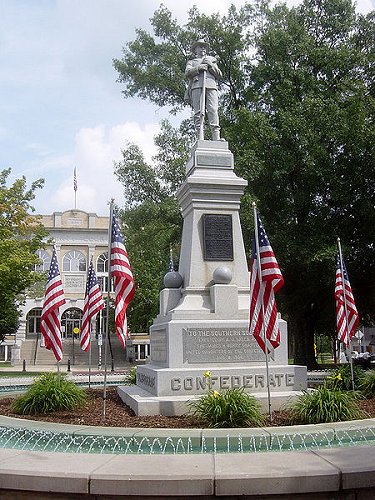
 Confederate Monument honoring James H. Berry and the Southern Soldier
Source: https://commons.wikimedia.org/wiki/File:09-02-06-BentonvilleConfed-monument.jpg
Author: Bobak Ha'Eri

Travel to Arkansas
The Little Rock National Airport (LIT), located a mere two miles from downtown Little Rock, is the main airport in Arkansas. It is not an international airport, but if coming from outside the U.S., you can easily transfer from any major U.S. airports to Little Rock. It is a pretty young airport which began operations only in 1997.Your transport options out of the airport includes the taxis, shuttles, limousines, rental cars and city buses.
Travel within Arkansas
The most practical form of transport for exploring Arkansas is by car. The main highway in Arkansas is Interstate-40, which crosses through the state from Fort Smith to Memphis, passing through Little Rock, and Interstate-30, which heads south to Texarkana. Walton's Five and Dime, now the Wal-Mart Visitors Center
Source: https://commons.wikimedia.org/wiki/File:09-02-06-OriginalWaltons.jpg
Author: Bobak

Cities in Arkansas
- Little Rock (192,000 / 863,000)
The capital and largest city in Arkansas. - Fort Smith (86,000 / 293,000)
Second largest city, located near the border with Oklahoma. - Fayetteville (73,000 / 421,000)
Third biggest city in Arkansas, and one of the four in Northwest Arkansas. - Springdale (60,000)
One of the four cities in Northwest Arkansas. - Hot Springs (39,000)
City renowned for its natural spring water. - Rogers (39,000)
Another city within the Fayetteville-Springdale-Rogers Metropolitan Area. - Bentonville (34,000)
Headquarters of Wal-Mart Stores, one of the four cities located to in Northwest Arkansas. - West Memphis (28,000)
City located across the Mississippi River from Memphis, Tennessee. - Texarkana (26,000)
This city straddles the border of Arkansas and Texas. Another 35,000 people live in Texarkana, Texas. - Searcy (21,600)
Home to Harding University, the largest private university in Arkansas. - El Dorado (21,500)
City at the southern border of Arkansas. - Hope (10,000)
Birthplace of President Bill Clinton
Places of Interest in Arkansas
- Buffalo National River
- Eureka Springs
- Magnolia
National Parks of Arkansas
 Latest updates on Penang Travel Tips
 Discover with Timothy YouTube Channel
 PG Food Channel
 Learn Penang Hokkien YouTube Channel
 SojiMart Videos
Latest from Discover with Timothy: Gurney Bay - what to see and do there
About this website

Hello and thanks for reading this page. My name is Timothy and my hobby is in describing places so that I can share the information with the general public. My website has become the go to site for a lot of people including students, teachers, journalists, etc. whenever they seek information on places, particularly those in Malaysia and Singapore. I have been doing this since 5 January 2003, for over twenty years already. You can read about me at Discover Timothy. By now I have compiled information on thousands of places, mostly in Peninsular Malaysia and Singapore, and I continue to add more almost every day. My goal is to describe every street in every town in Malaysia and Singapore.
Robbie's Roadmap
- Episode 1: Robbie's Journey to Financial Freedom
- Episode 2: Lost in America
- Episode 3: The Value of Money
- Episode 4: The Mentor
- Episode 5: The Thing that Makes Money
- Episode 6: The walk with a Billionaire
- Episode 7: The Financial Freedom Awakening
- Episode 8: Meet Mr Washington
- Episode 9: The Pizzeria Incident
Copyright © 2003-2024 Timothy Tye. All Rights Reserved.